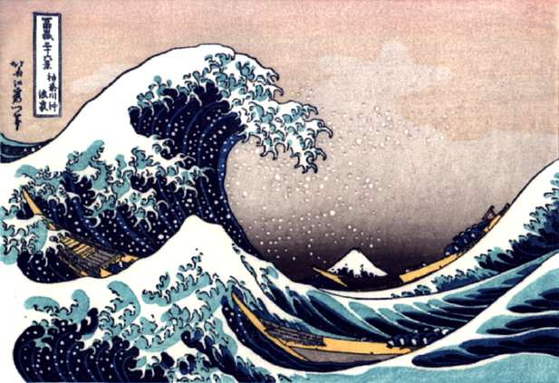
The Great Wave Off Kanagawa by Hokusai
The most famous Japanese Tsunami painting by the 18th Century artist Hokusai, full name Katsushika Hokusai (1760-1849).
The painting depicts a tsunami passing in front of Mount Fuji.
Tsunami
The Great Wave Off Kanagawa by Hokusai
The most famous Japanese Tsunami painting by the 18th Century artist Hokusai,
full name Katsushika Hokusai (1760-1849).
The painting depicts a tsunami passing
in front of Mount Fuji.
Dictionary Definition:
Tsunami. Noun. An extremely large wave caused by movement of the earth under the sea, often caused by an earthquake.
Tsunami is also the scientific word for a sea wave/sea surge generated by an undersea landslide¹, volcanic eruption, asteroid impact not to mention any man-made catalysts.
¹ The Dec 26th catastrophe (see below) was caused by an underwater quake.Tsunamis are also caused by terrestrial or submarine landslides.
Several cases of tsunamis caused by landslides have been recorded history. One such happened ± 2 million years ago when a block of 4 000 cubic kilometres slid off the Hawaii island of Oahu into the ocean causing a giant Tsunami.Misconception: A tsunami is not a tidal wave. It has nothing to do with tidal movements. "Tsunami"*
*Tsunami is the Japanese word for "harbour wave".
Defences, natural or man-made
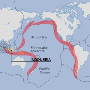
Although very rarely brought to the general public's notice, unless they reach such magnitudes as Dec 26th catastrophe, local or regional tsunamis do in fact occur several times every ten years, at different spots around the Pacific ocean's "Ring of fire".
The fact that the populations of tsunami risk coastal regions have increased sharply in recent years means that the death and injury tolls are higher today that it ever was.
The fact also that such regions are now prolific tourist resorts² means that there is also a highly developed media structure and with the acceleration in the transmission of media information news of such natural hazards is quasi-immediate bringing them global coverage.(² The Gross Domestic Product (GDP) of certain countries is reliant on tourism. Tourism in Thailand's represents 8% of the country's GDP.)
Man's implantation in these coastal zones has weakened natural defences leaving the zones open to erosion and destruction that would have otherwise been avoided had the defences, ex: indigenous mangrove swamps or coral reefs, not been clear to allow for tourist installations or prawn farming, as is the case in the Thailand.
Settlements, town and even cities have been built in estuaries and Deltas whose natural defences mechanisms, that once protected the regions against such severe natural hazards, have been weakened or totally removed. Dams are built upstream from these settlements hampering the natural depositing of sediment and silt in the estuaries leaving them open to erosion by the sea.Japan has a vast experience with such calamities and has intensively studied them and learnt lessons from them. The densely populated coastal regions on Japan's numerous islands now possess

Misconception: Tsunami walls are often no higher than a couple of meters and only provide a relative protection against the "Average" tsunami but are generally of no real protection against the more violent Tsunamis. Fortunately, the Japanese, being signatory of the Pacific TWS, are equipped with a highly effective electronic early warning system.
The PTWS (see below) continually informs the Japanese Meteo Agency of all tsunami and seismic activity, be it in the immediate vicinity or more generally around the entire ring of fire as earthquakes and landslides in Alaska or off the coast of Chile. This information is vital as such far away activities have as much an impact on Japan as does the seismic activity immediately off their coast*.
(* Due to the proximity and convergence of the Philippine & Pacific tectonic plates, just off the coast of Japan there is a particularly high seismic activity. As such tsunami warnings may be followed immediately by the Tsunami themselves, leaving the population little time to evacuate. Fortunately, however, the Japanese follow a very rigorous evacuation programme and as a result, the mortality rate of the tsunamis is often minimum.)
Other causes of Tsunamis
Unfortunately, not all tsunamis are the result of seismic activity and as such the seismic activity monitoring alone may not be enough to help warn against tsunamis generated by other causes. Landslides, asteroids or, unfortunately, human activity are other causes of tsunamis.
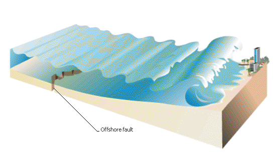
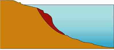
- Landslides. As mentioned above, landslides are another major cause of tsunamis. Landslides can be caused by earthquakes but also by tides, storm waves or sediment deposition movement.
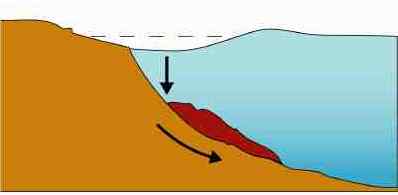
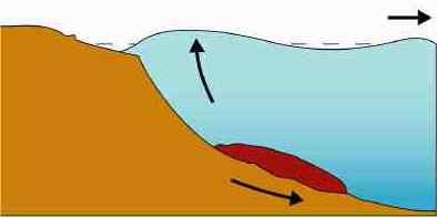
By definition, a landslide is caused by the downward sliding movement of a mass of sediment or rock. The sliding mass pushes the mass of water before it and sucks or pulls the water behind it. The frontal pushing effect elevates the water in front of the sliding land mass and a depression above and behind the landslide which is immediately filled by the frontal elevated mass of water thus creating the tsunami, see landslide graphic below.
- Asteroids. Although rare, asteroids are another cause of tsunamis, the most famous example probably being the asteroid that crashed into the Yucatan ± 65 millions years ago.
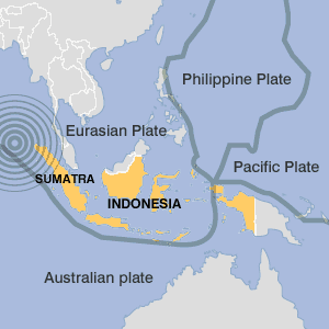
- Human activity. Human activity is another cause of Tsunamis. In an effort to understand severe natural climatic or geological hazards certain countries now have the technology to re-create calamities such as Hurricanes or earthquakes.Conspiracy specialists voiced the theory that the Dec 26th earthquake was a man-made simulation gone wrong and that one these numerous countries was trying to artificially re-create an earthquake. This theory is given a certain credibility as although Indonesia is on the Western rim of the "Ring of fire"* the Island of Sumatra has itself never experience an earthquake of such a magnitude. In fact, one of the reasons why the Indian ocean does not have a protection system as exists in the Pacific ocean is because the seismic activity in the Indian ocean is minimum, verging on the non-existent.
(* As Indonesia is part of the Pacific "Ring of Fire" the Japanese PTWS centre duly registered the seismic activity off Sumatra before the quake actually occurred. The only problem was that the PTWS centre had no pre-established contact or resources in or around the Indian ocean basin to warn local or regional authorities of the calamity that was soon to hit the region.)
Other man-made sources of tsunamis can be attributed to undersea drilling that may accidentally trigger seismic activity or underwater nuclear testing such as the French nuclear testings in the South Pacific before they were "Officially" stopped.
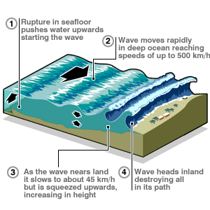
The mechanics of a Tsunami
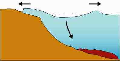
1- Seismic Tsunami
2- Landslide Tsunami
Facts:
- Fact: A tsunami may happen anywhere in the world, such as the in the Atlantic, not just around the Ring of Fire, a zone of volcanoes and seismic activity 32,500 km long, that encircles the Pacific Ocean.
- Fact: Since 1990 82 tsunamis have been reported, principally within the Pacific Ring of Fire.
- Fact: A major submarine slope failure in the N. Atlantic could give rise to a tsunami large enough to flood major cities on the coast of America or Europe.
- Fact: Mount St Helens (present on the map below). It has been calculated that if the Mount St Helens' eruption, in 1980, had happened underwater it would have created a 'tsunami/ tidal wave' with waves over ± 300 meters high.
- Fact: A tsunami can have a wavelength (distance between wave crests) in excess of 100km and with up to an hour between them. tsunami travel at great speeds across an ocean with hardly any energy losses and are barely noticeable out at sea.
- Fact: Over the deep Pacific Ocean, a tsunami travels at about 500mph. If an earthquake happened in Los Angeles, a tsunami could hit Tokyo quicker than it takes to fly between LA & Tokyo.
- Fact: Tsunami waves hitting coastlines can shift 20-tonne rocks hundreds of metres inland.
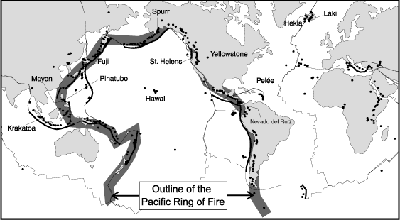
Pacific Ring of Fire
Exceptions to the rule
One notable exception to the above-mentioned rule happened approximately 7200 years ago, off the Norwegian coast, when an underwater landslide, called the 'Storegga' slide created a tsunami reaching West to Iceland and South to the Shetland Isles, totally devastating habitats and fauna of the affected regions*.
*NB. The British Geological Society, based in Edinburgh, evaluate the risk of submarine landslides and resulting tsunamis in the region, today, sufficiently serious to undertake extensive studies to gauge the consequences of such a natural hazard occurring today. While the impact of the 'Storegga' slide, ±7200 years ago, were sufficiently important, from a physical point of view, it's socio-economical impact was minimum. Today it's consequences would be radically different and the fact that the B.G.S. have recorded various other submarine movements underlines the importance of such a risk assessment.
Another exception is the Marmara sea region in the eastern Mediterranean, off the Turkish coast, leading to the Bosphorous and the Black sea. This area regularly witnesses tsunamis following earthquakes, such as happened in 1999.
Yet another exception, forecasted this time, and published on BBC.com, anticipates that a flank of the Cumbre Vieja volcano on the Canaries Las Palmas island is unstable and could plunge into the ocean, creating a landslide generated Tsunami(see above). Swiss researchers have modelled the landslide and estimate that half a trillion tonnes of rock falling into the water all at once would create a wave 650 metres high (2,130 feet) that would spread out and travel across the Atlantic. It would have a wavelength of 30 to 40 kilometres (18 to 25 miles) travelling westwards across the Atlantic at speeds up to 720 km/h (450 mph) towards America. The wall of water would weaken as it crossed the ocean, but would still be 40-50 metres (130-160 feet) high by the time it hit land. The surge would create havoc in North America as much as 20 kilometres (12 miles) inland..."
Scientists also estimate that the effects on African & European coastlines would be catastrophic. A wall of water a 100 meters high would totally submerge extensive regions of the West African coastline and devastate coastal regions
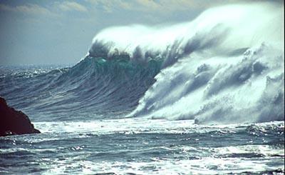
Causes and effects
A tsunami can race across the ocean at ± 500 mph and at sea its waves are only a few feet high with the waves increasing in energy and height, often with waves over 100 feet high, when the waves approach the coast. Often before a tsunami hits, there is a giant vacuum effect, and water is sucked from harbours and beaches.
NB. When tsunamis reach the coast they create a vacuum effect, causing sea water to retract from the shore which in turn feeds the approaching wave, alerting the population of the impending risk, giving them a certain amount of time to evacuate.
People can see the bare sea floor, uncovering fish and stranding boats. That is because waves are made out of crests and troughs. When a trough hits land first, the water level drops drastically. Usually, another wave blasts ashore about 15 minutes later, repeating the action for a while after the fist wave hits the shore. After a tsunami many people return to their homes, not realising that tsunamis come in groups, and the first not always the largest. Some of the most destructive damage caused by a tsunami is not from the arrival of the wave itself, but from the undertow, it creates as it leaves land and heads back to the sea.
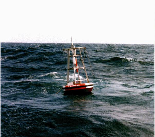
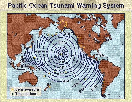
Records mention that Tsunamis killed more than 50,000 people during the course of the 20th century. In order to help saves lives, scientists established the Pacific Tsunami Warning System, based in Honolulu, Hawaii*, Its network of earthquake detectors and tide gauges detects quakes that may cause a tsunami and the monitoring of sea floor activity helps give warning of a potential tsunami and this warning may give as much as a few hours.
Other organisations, such as the NOAA, study and analyse tsunamis s a part of their global surveillance, creating simulations to better understand the impact of Tsunamis on the environment.
(*So seriously does the take tsunamis that Hawaiian authorities have issued instructions on what to do in case of a Tsunami and have elaborated plans informing people of flood zones and safety zones to which they may retreat.)
Because they are so certain of the facts and statistics, the PTWS never issues false or ill-founded warnings about Tsunamis simply because that any one given area around the Pacific 'Ring of Fire' can, one day or another, expect a visit from a tsunami and PTWS member states.
Dec 26/12/2004: A Date to Remember
December 26th, 2004. At ±10.15AM local time, the entire Indian ocean was struck by a series of Tsunamis resulting from an earthquake just off the north-west coast of Sumatra. Initially estimated at 8.9 on the Richter scale the earthquake was later upgraded to 9 on the Richter scale. The force of the quake was so strong that it was felt in Western Africa and with the tsunami reaching the East African coast, hitting Somalia, some five thousand miles to the west and causing the loss of over a hundred fishermen.
 |
 |
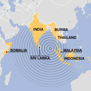 |
Technically speaking the Dec 26 earthquake and following Tsunami was the result of a movement in the Eurasian plate on the western side of the ring of fire but outside of the Tsunami Warning system's (TWS) surveillance zone set up around the ring of fire to monitor such seismic or tsunami activity.
NOAA/NGDCHowever the Indian ocean currently possesses no such warning system and the death toll impacted to the actual tsunami catastrophe, initially estimated at ± 30 000, is now reaching 150 000 as Indonesian authorities reach areas where communications and tourism are not as developed. The same applies as Indian authorities access territories such as the, hitherto, little known Andaman & Nicobar islands*. This could have been avoided had countries such as India and Indonesia been members of the International Warning System.
* NB. As with a lot of people, it's, unfortunately, true that it took the South East Asian earthquake & resulting tsunami to put places such as the Andaman and Nicobar Islands onto my personal World map. I had never heard of them before and it's a shame that the only time such places come to the attention of the general public is when a cataclysm hits them, such as when Cyclone "Zoe" devastated the Solomon Islands, Dec 28, 2002.
Credits: Many thanks to the NOAA for above mentioned info, images and links. All material appearing in this page is for a purely personal and documentary use.
©N.Richards 01/ 2005 & 11/2007